Einladung
Since 1.1.2018 we are in new rooms. We used this opportunity to redesign our museum for geoinformatics and to expand and significantly enlarge the picture gallery. We would be very happy if you came to the [...]
Since 1.1.2018 we are in new rooms. We used this opportunity to redesign our museum for geoinformatics and to expand and significantly enlarge the picture gallery. We would be very happy if you came to the [...]
Intergeo, roadshow and seminars are over and the winter season begins. This is the start of the ideal phase for the Learn & Earn seminars. Please contact us for information about dates for this year, including the proof of knowledge for drone pilots, which we have included in our seminar program [...]
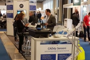
Measure easily and quickly - evaluate efficiently the faster, more precisely and more efficiently you do your field work, the more you can benefit. Measuring and drawing effectively has always been the maxim of the CADdy philosophy. We visited you at 4 venues [...]
The lossless thinning of large point clouds is a "must" if you want to work comfortably with CADdy® Classic, BricsCAD® or similar CAD systems. Current products have not produced the results that meet the demands for accuracy and performance. While in the range of 3D models [...]
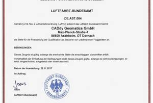
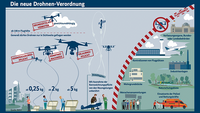
Regulations simplify the use of drones The new drone ordinance has given our profession a major headache. Many measurement flights became more complicated or completely impossible. We have added the Moving Surveyor procedure to cover this area with other recording methods. Now the air offices for [...]
CADdy goes BricsCAD Of course, the preparations for the 2018 version of CADdy Classiv V are already under way here as well. The focus will be on even closer cooperation with BricsCAD. In this context, there are a number of serious changes. Visit us [...]
Powerful 3D generator at a fair price This specially for CADdy extended version has been designed even more for demanding surveying tasks. In addition to the already well-known evaluation accuracy, this photo evaluation software impresses with many new features and a further improved computing speed. [...]