CADdy powered by 3Dsurvey
Not only in the field, surveying with the camera has completely changed the working world of the surveyor. In the office, too, strong photogrammetry software has turned our workflow to the exact coordinate. It does not matter if the photos come from a UAV (drone) or a terrestrial recording. Appropriate software calculates exact 3D models and orthophotos.
3Dsurvey has undergone a breathtaking development in recent months and has become a fascinating tool. Quickly and efficiently calculate photos from 3D models and orthophotos. Tools from the film industry and automotive technology make it possible.
But 3Dsurvey can do even more:
- Remove objects and fouling
- Recognition of targets
- Manage multiple horizons and discover masses in between
- Create sections in batch mode
- Output of many formats - CADdy cuts (lng, que) are just a few of the new features.
- New 3D functions also allow drawing and engineering in the 3D model
3Dsurvey turns your camera or smartphone into a high-precision surveying instrument. A well-coordinated workflow provides exact maps, coordinates or 3D models as a basis for further planning.
You can purchase 3Dsurvey as a standalone tool or as part of a complete “Moving – ” or “Flying Surveyor” training course.

colored 3D model

Dimensioning in 3D

Building from 3D
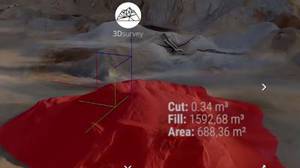
Masses from 3Dsurvey

high-precision terrain shots