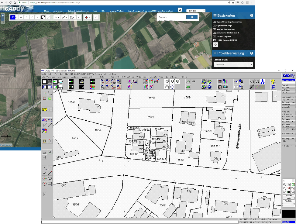
Web Map Services (WMS) are - in simple terms - interfaces for calling up map extracts of all kinds from the World Wide Web. These services are stored and offered on geodata servers by authorities, environmental and geological authorities and other geodata houses. The specification of these services is subject to a precise specification of the OGC (Open Geospatial Consortium). In other words - the syntax for accessing the services is practically always the same. As a user, you simply access a specific map section with a WWW URL (http: //… ..) and parameters in the URL and then have the data available in your software as a raster image (JPG, PNG, etc.). Incidentally, this also works in your browser. Try, for example:
You see an orthophoto of the shoreline of Lake Starnberg, retrieved with the freely available DOP80 (digital orthophoto - ground resolution 80cm) from the Bavarian surveying administration.
Users of the CADdy software palette can easily integrate various services, some of which contain global data, into their projects for many years. Be it a quick loading of a background photo or a cc-accurate cadastral map as the background of your CAD vector data. In addition to high-resolution aerial photographs, cadastral maps of the regional surveying offices are also available, as well as sunshine duration, georisks, recreational trails, road networks, topographical maps and much more.
You have never tried these (mostly free) services? Then it's high time, because there is so much to discover to refine your projects with this data!
We are happy to assist you within the framework of the CADdy software range or you can try out the WMS cards already integrated in CADdy Classic or WebCADdy.
In addition, we also offer paid services (aerial photographs with 20cm ground resolution, digital land maps, soil estimation, etc.) from the Federal Agency for Cartography and Geodesy (BKG) and the surveying authorities (eg Bavaria, Baden-Württemberg, North Rhine-Westphalia) as part of a monthly access fee , You do not have to contact the authorities yourself, we'll do it for you.
Ask us and contact our CADdy support via ph@wenninger.de or by phone (089) 427422 21.