with us you have better maps
The CADdy mapservice is an offer to visualize your data in so-called cloud services on the Internet. Your advantages: You do not need to invest in software or hardware. All costs are covered with the affordable monthly hosting fee. The creation of a "Mapserviceportal" is wizard-controlled, short and painless. The data can come directly from a WebCADdy project or from your CAD or GIS or be "connected". We use the extensive software library from WebCADdy, which allows easy creation and maintenance of geodata and the import / export of data. With a huge library of functions, almost every practical requirement for global geobased content management systems in the field of automotive, public transport, line documentation or construction site controlling can be covered.
In the "Geodata" area, we also supply or research the basic geodata or license official data and/or so-called POIs (points of interest). Your System needed. All systems are maintained and maintained according to the current EU data protection regulations and are hosted in a modern data center with extremely fast data connection (1000 Mbit) in Germany. If required, the hosting can also be carried out on own servers (please ask for an offer)
Here are examples from different topics:
Our examples
The possibilities of WebCADdy and the publication in its own WebGIS
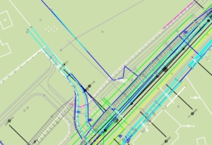
 measurement
Simple layout design with many different design options and surveying calculations
WebCADdy provides the ability to quickly and easily create complex CAD drawings. It is possible to import the most popular CAD and GIS formats and publish them after editing. In addition, many other functions common in CAD systems are available to you.
- Import of DXF / DWG data
- Layer management
- various CAD design options
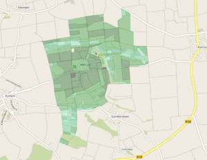
 land management
Powerful possibilities for the free design of land management projects
In this exemplary project and the following portal, we will show you the administration of land parcels (from the real estate cadastre), of buildings and areas of land estimation (land values). In freely configurable queries you can search for owners, find parcels that are affected by a pipe, for example, or you can focus on the soil estimate according to specific color schemes.
- Parcel management according to ALKIS standard
- Level or object management
- Import of shape and connection of kml data
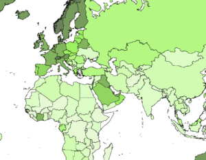 Statistics
Various statistical evaluations and visualizations
With the presentation of administrative areas (postcode areas, municipalities, administrative districts, countries, continents), this project / portal offers the opportunity to thematise and colorize these areas according to the values of the individual attributes (births, health, population, crime, etc.) ,
- thematic map display with rule editor
- Property Properties Management (Attribute Manager) in Form and List
- Analysis editor for generating factual analyzes
 Risk Management
Documentation and management of serious accidents and disasters
This project / portal offers a collection of the world's largest accidents and catastrophes ever registered, allowing visualization as well as factual and thematic evaluation.
- Connection of various WMS services
- spatial object analysis via SQL filter
- Connection of videos, photos and webcams
 Infrastructure
Management and representation of the technical and commercial infrastructure of a service area (commune, company premises, administrative district, etc.)
This project exemplifies the management of commercial POIs (accommodation, shopping, advertising space, grit, pipes, parking areas, street furniture, etc.)
- Location and address search
- Create and manage objects (points, lines and surfaces)
- Function menu (GPS on / off, distance and area measurement)
 Infrastructure traffic
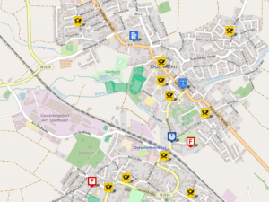
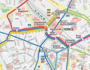
Infrastructure management (bus and tram lines, metro, distribution points, advertising space, subscribers, stops, etc.)
This project shows the infrastructure in public transport and visualizes these according to given drawing instructions. Due to the extensive analysis options, the project can be analyzed for all conceivable subject attributes and visualized accordingly. Thematic maps are also provided.
- Connection of various WMS services (eg aerial view, cadastre)
- spatial object analysis via SQL filter and thematic representation via rule editor
- Attach videos, photos or webcams
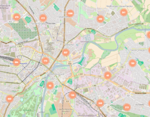 sales logistics
Administration and visualization of complex sales structures
This portal visualizes customer locations, sales territories and, if necessary, calculates tours and routes and, if equipped, also displays mobile objects (eg field service vehicles)
- customer management
- Sales Territory Management
- spatial object analysis
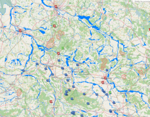
Energy
Management and visualization of the infrastructure (pipelines, gas, water, electricity, sewer, cable, etc.) with the appropriate specialist attributes of line operators and municipal utilities
This project shows the technical infrastructure of a municipal line operator and visualizes these according to given drawing instructions. Due to the extensive analysis options, the project can be evaluated, analyzed and visualized according to all conceivable attribute attributes. Thematic maps are also provided.
- any factual data depth
- Drawing instructions via layout manager
- spatial object analysis via SQL filter and thematic representation via rule editor
CADdy landfill
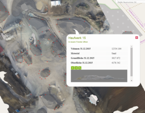 Management and visualization of landfills and heaps
This project shows the management and documentation of measurement results from landfill and gravel surveys with UAVs (unmanned aerial vehicles)
- Mass determination and documentation
- Attach your own aerial photo with aerial photograph history
- Data management with schedule
Agriculture
Management of agricultural projects and cultivated land. Visualization of the cadastre situation and fertilizer distribution and yield mapping.
This portal makes it easy to map agricultural land (cadastre, lease, yield, fertilizer, cultivation) and to allocate a corresponding attribution. It allows the data analysis and corresponding representation also with thematic representation (yield, fertilizer use, traction tracks)
- Easy mapping of agricultural interesting areas also from GPS survey
- Display of lanes and tracks
- Object analysis via SQL filter and thematic representation via rule editor
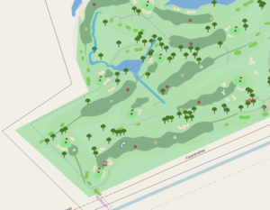 Sports Course Management
Management and documentation of sports fields in general and golf courses in particular
This portal makes it easy to document and maintain sports areas (greens, fairways, drainage pipes, tees, fallow land, fertilizer, sports grounds, mowing, etc.) and to assign a corresponding attribution. It allows the data analysis and corresponding representation also with thematic representation (yield, fertilizer use, traction tracks)
- Integration of any WMS services (cadastre, aerial photo)
- Easy mapping sporttechnisch interesting surfaces also from GPS Surplus
- Object analysis via SQL filter and thematic representation via rule editor
Feature list - functions WebCADdy / WebGIS
WebCADdy has all the powerful features that make up a modern GIS and telematics system. Almost all features are available in WebCADdy (all-in-one except routing and navigation). In the explicit portals (WebGIS) only the functions that the operator desires are offered.
- Without control
- Login with ID and password
- Rights management and role management
- Registration Management
- Create new projects
- Manage existing projects
- Delete projects
- Export / import of projects in CAD and GIS formats
- Transfer of projects directly to WebGIS
- Standard Basemap OpenStreetMap
- Expandable Google or Bing Maps (paid)
- WMS services official (cadastre, aerial photos, location maps ...)
- WMS services private (D-SAT, ...)
- Various display forms for view and edit (freely configurable in the future)
- Display of the entry as independent website (dynamic website generator)
- Zooming beyond the OpenLayers standard (up to zoom level 25 = approx. 5 x 5 m)
- Free moving (pan)
- Zoom to (project, object ...)
- Pull neckline up and zoom out
- Tooltip with minimized object properties
- Responsive design for display on any devices and operating systems
- Address
- Radius search
- Property search
- Drawing points
- Drawing lines
- Drawing surfaces
- Drawing texts
- Drawing circles
- Drawing ellipses
- Removal
- Area
- Record GPS (point, line, area)
- Connect external precision GPS (blueCADdy - currently only for Android)
- Import measurement photos and calculate position from forward cut
- Import measurement data
- Directional angle and distance
- Send meeting point
- Create and output object description as PDF
- Start navigation to POI (NaviAPP must be installed on terminal)
- Dynamic distance measurement to a defined object
- Automatic location (point in area)
- Automatic creation of area tags (QR tag with position and access to the portal and the POI)
- point snap
- line fishing
- endpoint
- Focus
- parallel
- intersection
- Search and show object (also wildcard) via map and list
- Complex queries via SQL-Wizard, also nested and arbitrarily deep
- Complex queries also spatially (spatial request)
- Complex queries for buffer elements (show all objects in 100 m distance along ...)
- Freely definable buffer elements (circle, area or line)
- Thematic analyzes and queries via rule editor
- Free tiering and color scale assignment
- Storage option for thematic queries
- Calling stored queries or thematic maps
- Free object type administration
- New object
- Delete object
- Copy object
- Copy object type
- Manage attribute types of an object (name, description text, number, mail, photo, video, website)
- Create and delete attributes
- View and edit attributes in list form
- Show location
- Plan route
- Start navigation via Navigationsapp (must be installed)
- Transfer position to central fleet monitor database (IV)
- Set and manage object-specific layout (point, line, area and text)
- Zoom level assignment of a layout (zoom-sensitive layout)
- Line and area color, line width, line style and transparencies
- Symbol allocation
- Brief assignment
- Free printing of the visible section via the browser
- Export CAD and GIS formats (Shape, DXF, CADdy PIC, CSV)
- Export to SQLite (WebCADdy, CADdy JGIS)
- Direct export into existing WebGIS projects
- Open mail client and send single mail
- Send serial mail (Export .vcf for mail client)
- Addition of geo objects
- Change to Flatfeebrechnung
- customer management
- Moving in through Paypal