What does our Learn & Earn seminar “WebCADdy & WebGIS” offer
Working with a mobile GIS - as a graphical field book with GNSS support and as a data hub with extensive import and export functions
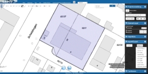
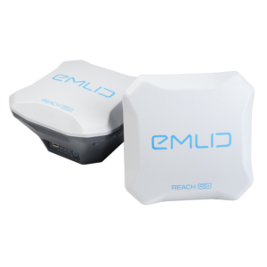
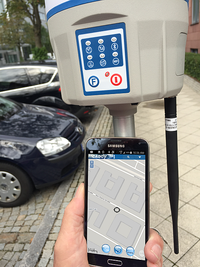
We will show you how to use WebCADdy, take care of access controls and configure a project. Then we import data from one of your projects, no matter what data basis you have, edit them and define SQL queries and in turn integrate them into the project as a map view that can be switched on / off. We explain the simple drawing technique, how to measure centimeters precisely with GPS, edit attribute schemes and much more.
In the second step, we design our own portal, e.g. your city, municipality or administrative district, using our configurator, determine the layout and functionality of the portal and upload the WebCADdy project to this portal. Then we define the orientation database (e.g. a free city map or an aerial photo service, additionally define useful WMS services, define the layout for the vector data and import the SQL filters and analyzes. The portal created is responsive, i.e. available on all end devices. Finally, we provide information You can find out about the various price models (flat rate or object-based) for using this technology.
Learn
Introduction to WebCADdy, drawing, editing, connection to GNSS Reveiver and configuration for Sapos / Axio and further processing in GIS (CAD
Earn
Please note our respective introductory offers with discounted conditions for current GNSS receivers
Individually customizable
WebCADdy is individually customizable and configurable, employee administration, layout design, GIS analyzes, thematic maps, project management and individual geoportals are to create in WebCADdy at any time and to maintain continuously.
independent sensor
Nobody needs to use CADdy in our seminar, we show you how to achieve an excellent result with different software solutions. Both the evaluation with web services and the high-end solutions are in our program. You decide which way you want to go.
Expand your knowledge
Our training program guides you step by step through the possibilities of WebCADdy.
How does the seminar work?
In the Learn & Earn seminar "WebCADdy" you will learn
Our offers for you
The aim of these seminars is to familiarize you with our new mapping and information technology and the CADdy products and to provide you with a geoportal created during the training as a benefit.
Offer 1
- Training, Setup, 1 Year Free Use (1AP)
Offer 2 incl. GNSS receiver
- Training, setting up, evaluating in a course