The CADdy Geomatics Academy offers training on UAV drones, which includes technical surveying training. The company of the same name wants to create the conditions for the drone market to be able to develop dynamically and at the same time in a legally secure manner in this country.
If you want to carry out survey flights, you need the necessary driver's license. This is enshrined in law at European Union level. The large EU drone pilot's license (EU long-distance pilot's certificate A2) must be taken at test centers that are certified by the Federal Aviation Authority (LBA). The CADdy Academy is one of over 20 certified training centers. As a unique selling point in Germany, it integrates professional training for the special needs of surveying. It is based on products and workflows from CADdy Geomatics GmbH and Wenninger Geoinformatik. The range of seminars is aimed at both beginners and professional users. The spectrum of topics ranges from classic CAD to professional sensor programs and revolves around the “Flying, Swimming and Moving Surveyor” solutions in particular.
Flying Surveyor - more workflow than job title
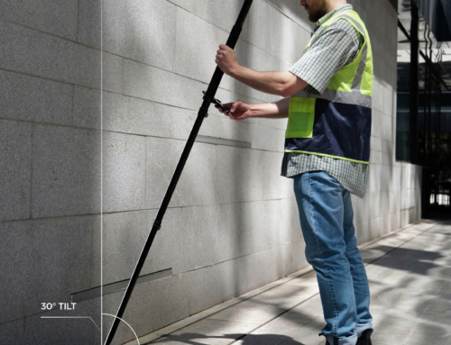
The term Flying Surveyor is not a job title, but defines a workflow that CADdy Geomatics has developed on the basis of surveying and photogrammetric know-how in order to achieve good measurement results even with simple drones. "In the early years, professional users from the surveying world were still reluctant to use this technology," stresses Michael Wenninger. The causes were the high capital investment for the flying equipment, insufficient measurement results and poor accuracy of the result point clouds. In the meantime, however, work with survey drones (GeoUAVs) has established itself as an important and successful tool. "No other surveying device offers such a potential for simplification and time savings as the GeoUAV in small-scale photogrammetric surveying," says Wenninger. However, it is in the nature of things that one-day training is not possible. "Three days is the absolute minimum for such training."
Therefore, the most important topics such as flight law, practical training and evaluation are summarized in this period. In this context, future pilots can test their flying skills both in an area directly next to the seminar rooms and in a gravel mining area. Practical cross-country flights and tests can also be carried out in the Flying Surveyor training center. At the end of the training, the long-distance pilot exam (A2 license) is taken. The "Flying Surveyor" workflow therefore also handles tasks that reach down to millimeter precision. "But the core competences basically lie in simplifying the surveying technology in order to get better and faster results," says Wenninger. The training consists of many components. The basic offer includes a standard UAV (DJI P4P). Upgrading to more powerful UAV types can be done. In any case, participants fly their own projects with their own drone. The training includes the partly new legal requirements of the EASA. Another goal of the training is the training of flight planning. There are extensive libraries in the flight planning software for this purpose.
Video technology for the 3D modelling
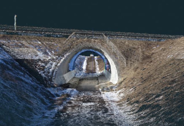 With the inclusion of video technology in the imaging process, further possibilities have arisen to generate image material for 3D evaluation quickly and effectively, even in the most difficult environments. The required image is determined by software from the video stream and the 3D point cloud is calculated from this, as with the single image solution. According to Wenninger, it is interesting for this video measurement that data from smartphone and conventional camera recordings can also be used - even if they have different qualities. Software solutions such as CADdy 3Dsurvey also have a function for video evaluation. "The required individual recordings are calculated from the stream and included in the classic calculation," says Wenninger. The "video images" do not have georeferencing, which is listed in the EXIF headers and footers for individual images, and their resolution is also lower.
But with the method deposited with the Flying Surveyor, a surveyor still achieves his goal. "In extensive tests, we were able to determine accuracies that are completely sufficient for building monitoring or quantity determinations," says Wenninger. The workflow assumes, for example, that a homogeneous control point field is used. Structures that have underground or overhanging components, such as bridges or buildings with passageways, are particularly suitable for the video method. This combined method of classic and video photogrammetry is suitable for securing evidence, for example. A flight through a narrow tunnel is also possible, "although you have to pay attention to the structural characteristics of the structure here," says Wenninger. A steel-reinforced structure, for example, also has special magnetic conditions, which means that the compass of the drone is strongly deflected and it can sometimes no longer be controlled. The same applies to continuous power lines. The local pressure conditions also affect the barometer, which should therefore be switched off on such flights.
Interview with Michael Wenninger, who took over the management of the company from his father and company founder Helmut Wenninger three years ago Commercial Manager Axel Dannenbauer.
EU law has been in force for the legal regulations of UAV operation since 2019, which was then translated into the respective implementation of state law. What does this shift in regulation from the state or federal to the EU level mean in practice?
Axel Dannenbauer: This poses major challenges for the executing companies – and especially the training companies. Of course we want to make it as easy as possible for the pilots. On the other hand, we attach great importance to adhering to the current regulations in order not to diminish the acceptance for the use of UAVs and to put them to the test again and again.
Michael Wenninger: We are in close contact and exchange with the aviation authorities to find practicable solutions. In connection with the implementation of the new EASA legislation, we can often observe that people are deliberately ignoring it because it has become too complicated. This is dangerous and can lead to many new regulations and bans. Of course we don't want that. We therefore recommend extensive training in which we show how and when you can work with UAVs with reasonable effort.
There is the open category, where the approval hurdle is significantly lower. Isn't that a way out for surveyors?
Axel Dannenbauer: We try to allocate as many flights as possible to the open category, but mostly we are in difficult surroundings, with uninvolved people or groups of people in the recording area or in urban terrain or directly over motorways, federal roads and other traffic restrictions. Then it is a matter of the category requiring approval (Certified). This always requires an operating license and a SORA or ConOps - and that's where it gets complicated.
So far, according to the new EU regulation, bei UAS operation in the open category, not between commercial and private use distinguished.
Michael Dannenbauer: Yes, so far! But the Federal Ministry for Digital and Transport decided on changes in early 2022. A minimum horizontal distance of 30 meters must now be maintained from uninvolved persons. If the UAS is operated in a separate slow flight mode and the operator ensures that a maximum speed of 3 m/s is not exceeded, the minimum horizontal distance is only 5 meters.
Wasn't there even talk of 50 meters in the transitional regulation until December 31.12.2022, XNUMX?
Axel Dannenbauer: Correct! However, the ministry believed that these limitations would severely limit the UAS's ability to operate in urban areas, often making it impossible to operate in the open category in urban settings. So we can now fly a little closer to uninvolved people with our existing drones and an A2 long-distance pilot's certificate. Of course, all the other rules still apply, but there's some relief here. Unfortunately, this decree is only valid until August 31.08.2022, XNUMX, so we can only be really happy for a short time.
What does that mean in the long term?
Axel Dannenbauer: From our point of view, everyone who uses the UAS in a professional environment will sooner or later not be able to avoid the SORA ConOps package. All questions about the A2 long-distance pilot's certificate, SORA-ConOps or other topics related to the use of UAS in the surveying area are explained in detail in our "flying surveyor" training plan.
What is the role of the UAV's own Software solutions for flight planning?
Michael Wenninger: In principle, a number of restrictions have been stored at DJI for years, which must be observed for every flight plan. In addition to flight altitude and speed, prohibited zones are also monitored. So you can not climb near NoFlyZones or you are asked to obtain a special permit. In principle, the flight is logged exactly, which practically replaces the previously used flight log. Of course, this leads to dissatisfaction with some users, as they feel monitored. However, we think this specification makes sense, as it serves to differentiate between professional and non-professional users. DJI has incorporated a whole range of improvements in the new versions, also based on our direct recommendations. DJI always impresses us how professionally they deal with our suggestions for the further development of the solutions and how quickly requests are implemented.
Which are they specifically?
Michael Wenninger: The restrictions on the planning can be lifted, for example, if there is a corresponding request. There are two stages. At the first level, you confirm the sensible use and compliance with the specifications, at the highest level, written confirmation must be requested from DJI. In order to facilitate these steps, new, specific flight plans have been added, for example for inclined and vertical flights for complicated structures or the inclusion of our own surface models for terrain-sensitive flight profiles or additions and refinements to existing flight arrangements, such as cross and parallel flights with different recording directions.
Why are these changes so important for surveyors?
Michael Wenninger: Because different tasks require a different approach to flight planning. Flights on sloping terrain or even in mountain regions with steep valleys require a completely different flight planning than a gravel quarry or a golf course on flat terrain.
So is specialist training for UAV-based surveying urgently needed?
Axel Dannenbauer: We have also discussed this topic in detail with the Federal Aviation Authority. The demands on the farmer, the building surveyor, the hunter, the parcel deliverer or the photographer are fundamentally different, sometimes diametrically different. Of course we understand if the Federal Aviation Authority has uniform rules wants to create and that's right. In the training to become a "Flying Surveyor", however, completely different aspects apply, the same rules, but a completely different approach. Our pilots mainly fly in the most difficult environments, over urban terrain, over people or close to endangered buildings and public transport routes, so a complex approval process would be necessary in half of the cases.
Michael Wenninger: Our areas of application are wherever there is construction or surveying. Getting a permit for a flight is often not possible in terms of time. The deadlines are determined by the progress of construction and not by the processing time in an authority. Sometimes there are daily flights, the construction progress is monitored or masses are determined. So you will always look for flight options and flight plans that make a complex ConOp or SORA superfluous, but still deliver good, reliable results. Especially in the transition phase, in which no certified UAVs and standard scenarios are available, the training must show exactly these possibilities. It doesn't help anyone if the surveyors flee into illegality and operate where they shouldn't, with the excuse "nobody sees anyway". Surveying with drones and GPS is too important today to be carelessly jeopardized.
The CADdy Geomatics Training Plan 2022
- 15 May 2024
Flying Surveyors Seminar
15 May 2024 - 17 May 2024
CADdy Geomatics GmbHWith us you will learn the entire workflow from aerial surveying to mass calculation and the subsequent presentation for your customers. In addition, a DJI Phantom 4 is included in the price. Our training program guides you step by step through the complex processes of measuring with aircraft. From simple flight training, complex waypoint planning, photo shooting, evaluation of the shots to a 3D model and mass calculation.
- 16 May 2024
Flying Surveyors Seminar
15 May 2024 - 17 May 2024
CADdy Geomatics GmbHWith us you will learn the entire workflow from aerial surveying to mass calculation and the subsequent presentation for your customers. In addition, a DJI Phantom 4 is included in the price. Our training program guides you step by step through the complex processes of measuring with aircraft. From simple flight training, complex waypoint planning, photo shooting, evaluation of the shots to a 3D model and mass calculation.
- 17 May 2024
Flying Surveyors Seminar
15 May 2024 - 17 May 2024
CADdy Geomatics GmbHWith us you will learn the entire workflow from aerial surveying to mass calculation and the subsequent presentation for your customers. In addition, a DJI Phantom 4 is included in the price. Our training program guides you step by step through the complex processes of measuring with aircraft. From simple flight training, complex waypoint planning, photo shooting, evaluation of the shots to a 3D model and mass calculation.
Examination A2 remote pilot certificate
17 May 2024
CADdy Geomatics GmbH, Schatzbogen 65, 81829 Munich, Germany
- 23 May 2024
Swimming Surveyor Seminar
23 May 2024 - 24 May 2024
CADdy Geomatics GmbHOur training program guides you step by step through the complex processes of underwater surveying. From simple driving training, complex waypoint planning to the evaluation of the recordings right up to the 3D model. You will learn the basics of underwater surveying, how to use the measuring boat, waypoint planning, the preparation of depth data, the complete evaluation (from the point to the georeferenced 3D model) and the further processing of the data in your CAD program (profiles, mass calculation, contour lines).
- 24 May 2024
Swimming Surveyor Seminar
23 May 2024 - 24 May 2024
CADdy Geomatics GmbHOur training program guides you step by step through the complex processes of underwater surveying. From simple driving training, complex waypoint planning to the evaluation of the recordings right up to the 3D model. You will learn the basics of underwater surveying, how to use the measuring boat, waypoint planning, the preparation of depth data, the complete evaluation (from the point to the georeferenced 3D model) and the further processing of the data in your CAD program (profiles, mass calculation, contour lines).
Examination A2 remote pilot certificate
24 May 2024
CADdy Geomatics GmbH, Schatzbogen 65, 81829 Munich, Germany
- 31 May 2024
Examination A2 remote pilot certificate
31 May 2024
CADdy Geomatics GmbH, Schatzbogen 65, 81829 Munich, Germany
- June 14, 2024
GNSS seminar
June 14, 2024
CADdy Geomatics GmbHIntroduction to WebCADdy, drawing, editing, connection to GNSS Reveiver and configuration for Sapos / Axio and further processing in GIS (CAD). The aim of this seminar is to familiarize you with our new mapping and information technology and CADdy products and to provide you with a geoportal created as part of the training.
Examination A2 remote pilot certificate
June 14, 2024
CADdy Geomatics GmbH, Schatzbogen 65, 81829 Munich, Germany
- June 19, 2024
Flying Surveyors Seminar
June 19, 2024 - June 21, 2024
CADdy Geomatics GmbHWith us you will learn the entire workflow from aerial surveying to mass calculation and the subsequent presentation for your customers. In addition, a DJI Phantom 4 is included in the price. Our training program guides you step by step through the complex processes of measuring with aircraft. From simple flight training, complex waypoint planning, photo shooting, evaluation of the shots to a 3D model and mass calculation.
- June 20, 2024
Flying Surveyors Seminar
June 19, 2024 - June 21, 2024
CADdy Geomatics GmbHWith us you will learn the entire workflow from aerial surveying to mass calculation and the subsequent presentation for your customers. In addition, a DJI Phantom 4 is included in the price. Our training program guides you step by step through the complex processes of measuring with aircraft. From simple flight training, complex waypoint planning, photo shooting, evaluation of the shots to a 3D model and mass calculation.
- June 21, 2024
Flying Surveyors Seminar
June 19, 2024 - June 21, 2024
CADdy Geomatics GmbHWith us you will learn the entire workflow from aerial surveying to mass calculation and the subsequent presentation for your customers. In addition, a DJI Phantom 4 is included in the price. Our training program guides you step by step through the complex processes of measuring with aircraft. From simple flight training, complex waypoint planning, photo shooting, evaluation of the shots to a 3D model and mass calculation.
- June 27, 2024
CADdy for BricsCAD seminar
June 27, 2024 - June 28, 2024
CADdy Geomatics GmbHBricsCAD® has established itself as the number 1 alternative for AutoCAD® and offers convenient options for processing DWG and DXF data without any significant restrictions. If you want to run CADdy together with BricsCAD or AutoCAD, that's no problem. Start the program from CADdy Classic V, which is linked to DWG in Windows. CADdy automatically transfers the current project and important settings.
- June 28, 2024
CADdy for BricsCAD seminar
June 27, 2024 - June 28, 2024
CADdy Geomatics GmbHBricsCAD® has established itself as the number 1 alternative for AutoCAD® and offers convenient options for processing DWG and DXF data without any significant restrictions. If you want to run CADdy together with BricsCAD or AutoCAD, that's no problem. Start the program from CADdy Classic V, which is linked to DWG in Windows. CADdy automatically transfers the current project and important settings.
Examination A2 remote pilot certificate
June 28, 2024
CADdy Geomatics GmbH, Schatzbogen 65, 81829 Munich, Germany
- July 10, 2024
Flying Surveyors Seminar
July 10, 2024 - July 12, 2024
CADdy Geomatics GmbHWith us you will learn the entire workflow from aerial surveying to mass calculation and the subsequent presentation for your customers. In addition, a DJI Phantom 4 is included in the price. Our training program guides you step by step through the complex processes of measuring with aircraft. From simple flight training, complex waypoint planning, photo shooting, evaluation of the shots to a 3D model and mass calculation.
- July 11, 2024
Flying Surveyors Seminar
July 10, 2024 - July 12, 2024
CADdy Geomatics GmbHWith us you will learn the entire workflow from aerial surveying to mass calculation and the subsequent presentation for your customers. In addition, a DJI Phantom 4 is included in the price. Our training program guides you step by step through the complex processes of measuring with aircraft. From simple flight training, complex waypoint planning, photo shooting, evaluation of the shots to a 3D model and mass calculation.
- July 12, 2024
Flying Surveyors Seminar
July 10, 2024 - July 12, 2024
CADdy Geomatics GmbHWith us you will learn the entire workflow from aerial surveying to mass calculation and the subsequent presentation for your customers. In addition, a DJI Phantom 4 is included in the price. Our training program guides you step by step through the complex processes of measuring with aircraft. From simple flight training, complex waypoint planning, photo shooting, evaluation of the shots to a 3D model and mass calculation.
Examination A2 remote pilot certificate
July 12, 2024
CADdy Geomatics GmbH, Schatzbogen 65, 81829 Munich, Germany
- July 26, 2024
Examination A2 remote pilot certificate
July 26, 2024
CADdy Geomatics GmbH, Schatzbogen 65, 81829 Munich, Germany
- August 16, 2024
Examination A2 remote pilot certificate
August 16, 2024
- August 30, 2024
Examination A2 remote pilot certificate
August 30, 2024
- September 6, 2024
open-door day
September 6, 2024
The 20s also brought many changes in the field of geoinformation and surveying. We want to discuss the important things with you and present them compactly in a pleasant atmosphere. As a gentle start into the new year, we will show you the newly designed exhibition "Geoinformatics in the Mirror of Time" with the picture exhibition by the artist Heidi Schneider "Terrain Structures". (All images can also be purchased as a pleasant office design.)
- We show the new one on the Geomuseum tour Touchscreen GIS station of "City Atlas Munich“And explain how historical maps from 1000 years in connection with modern ones WebGISystems (Green space, golf course, park cadastre) harmonize.
- In the lecture "Surveying 4.0 - modern 3D data acquisition“We show what changes engineering surveying has made in recent years surveying robot (Flying, swimming, moving surveyor) and high-performance 3D photogrammetry mathematics experienced.
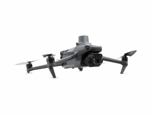
- After this lecture we make one Live flight familiar with the Mavic 3Enterprise - the currently best survey drone - including an evaluation - via our control point field and briefly explain the major changes that the European EASA regulation will bring about for pilots.
- The CADdy Support colleagues Peter Hanft and Andreas Maier will show you what new features CADdy software systems have to offer and in connection with "WebCADdy"The field work (measuring, staking out, planning) is so simplified and how you"terrain-sensitive flight planning" with the new height server can perform.
- Planning offensive Bavaria: Together with our development partner aRES data systems, we will show you our systems for sewer rehabilitation. Bavaria in particular has launched an extensive funding program to promote sewer rehabilitation projects. Together with the market leader aRES data systems we have released an AutoCAD / BricsCAD version for quick planning.
- Test the new one SuperGNSS generation, the Price hit from Emlid at our Sapos checkpoints or try the extended "indirect recording methods“With which you get top results even under poor conditions (trees or house corners).
- Test the function "Measure offline“With which you can measure and save in WebCADdy even without an Internet connection.
Of course, your physical well-being is taken care of and the CADdy Catering Team will take care of you as usual. So that the event is also financially interesting for you, the participants will receive a lucrative voucher code that can be redeemed with the next purchase and will count towards our already low prices.
So we tackle the 20s and start again. About your visit we would be very happy.- We show the new one on the Geomuseum tour Touchscreen GIS station of "City Atlas Munich“And explain how historical maps from 1000 years in connection with modern ones WebGISystems (Green space, golf course, park cadastre) harmonize.
- September 11, 2024
Flying Surveyors Seminar
September 11, 2024 - September 13, 2024
CADdy Geomatics GmbHWith us you will learn the entire workflow from aerial surveying to mass calculation and the subsequent presentation for your customers. In addition, a DJI Phantom 4 is included in the price. Our training program guides you step by step through the complex processes of measuring with aircraft. From simple flight training, complex waypoint planning, photo shooting, evaluation of the shots to a 3D model and mass calculation.
- September 12, 2024
Flying Surveyors Seminar
September 11, 2024 - September 13, 2024
CADdy Geomatics GmbHWith us you will learn the entire workflow from aerial surveying to mass calculation and the subsequent presentation for your customers. In addition, a DJI Phantom 4 is included in the price. Our training program guides you step by step through the complex processes of measuring with aircraft. From simple flight training, complex waypoint planning, photo shooting, evaluation of the shots to a 3D model and mass calculation.
- September 13, 2024
Flying Surveyors Seminar
September 11, 2024 - September 13, 2024
CADdy Geomatics GmbHWith us you will learn the entire workflow from aerial surveying to mass calculation and the subsequent presentation for your customers. In addition, a DJI Phantom 4 is included in the price. Our training program guides you step by step through the complex processes of measuring with aircraft. From simple flight training, complex waypoint planning, photo shooting, evaluation of the shots to a 3D model and mass calculation.
Examination A2 remote pilot certificate
September 13, 2024
CADdy Geomatics GmbH, Schatzbogen 65, 81829 Munich, Germany
- September 25, 2024
InterGeo Stuttgart 2024
September 25, 2024 - September 27, 2024
Also this year we will present our latest products and services as an exhibitor at the InterGeo and look forward to your visit!
Would you like to meet us at InterGeo 2024?
Then sign up below 089 427422 - 22 and you will receive a free ticket.
- September 26, 2024
InterGeo Stuttgart 2024
September 25, 2024 - September 27, 2024
Also this year we will present our latest products and services as an exhibitor at the InterGeo and look forward to your visit!
Would you like to meet us at InterGeo 2024?
Then sign up below 089 427422 - 22 and you will receive a free ticket.
- September 27, 2024
InterGeo Stuttgart 2024
September 25, 2024 - September 27, 2024
Also this year we will present our latest products and services as an exhibitor at the InterGeo and look forward to your visit!
Would you like to meet us at InterGeo 2024?
Then sign up below 089 427422 - 22 and you will receive a free ticket.
- 4 October 2024
3Dsurvey seminar
4 October 2024
CADdy Geomatics GmbHYou will learn the entire workflow from mass calculation to the subsequent presentation to your customers. It is not only in the field that measurement with the camera has completely changed the working world of the surveyor. In the office, too, strong photogrammetry software has turned our workflow into an exact coordinate. It doesn't matter whether the photos come from a UAV (drone) or a terrestrial image. With suitable software, exact 3D models and orthophotos are calculated.
- 9 October 2024
Flying Surveyors Club Day
9 October 2024
CADdy Geomatics GmbHOn this workshop day (free for members) we work on changing topics.
for example:
- Mavic 3 Enterprise tips and tricks
- Current legal situation
- drone harmony
- Training of new functions 3Dsurvey
- the best 3rd party flight planning
- Refresher on current legal issues
- Discussion of individual assignments
- 16 October 2024
Flying Surveyors Seminar
16 October 2024 - 18 October 2024
CADdy Geomatics GmbHWith us you will learn the entire workflow from aerial surveying to mass calculation and the subsequent presentation for your customers. In addition, a DJI Phantom 4 is included in the price. Our training program guides you step by step through the complex processes of measuring with aircraft. From simple flight training, complex waypoint planning, photo shooting, evaluation of the shots to a 3D model and mass calculation.
- 17 October 2024
Flying Surveyors Seminar
16 October 2024 - 18 October 2024
CADdy Geomatics GmbHWith us you will learn the entire workflow from aerial surveying to mass calculation and the subsequent presentation for your customers. In addition, a DJI Phantom 4 is included in the price. Our training program guides you step by step through the complex processes of measuring with aircraft. From simple flight training, complex waypoint planning, photo shooting, evaluation of the shots to a 3D model and mass calculation.
- 18 October 2024
Flying Surveyors Seminar
16 October 2024 - 18 October 2024
CADdy Geomatics GmbHWith us you will learn the entire workflow from aerial surveying to mass calculation and the subsequent presentation for your customers. In addition, a DJI Phantom 4 is included in the price. Our training program guides you step by step through the complex processes of measuring with aircraft. From simple flight training, complex waypoint planning, photo shooting, evaluation of the shots to a 3D model and mass calculation.
Examination A2 remote pilot certificate
18 October 2024
CADdy Geomatics GmbH, Schatzbogen 65, 81829 Munich, Germany
- 24 October 2024
GNSS seminar
24 October 2024
CADdy Geomatics GmbHIntroduction to WebCADdy, drawing, editing, connection to GNSS Reveiver and configuration for Sapos / Axio and further processing in GIS (CAD). The aim of this seminar is to familiarize you with our new mapping and information technology and CADdy products and to provide you with a geoportal created as part of the training.
- 25 October 2024
Examination A2 remote pilot certificate
25 October 2024
CADdy Geomatics GmbH, Schatzbogen 65, 81829 Munich, Germany
- 14 November 2024
CADdy for BricsCAD seminar
14 November 2024 - 15 November 2024
CADdy Geomatics GmbHBricsCAD® has established itself as the number 1 alternative for AutoCAD® and offers convenient options for processing DWG and DXF data without any significant restrictions. If you want to run CADdy together with BricsCAD or AutoCAD, that's no problem. Start the program from CADdy Classic V, which is linked to DWG in Windows. CADdy automatically transfers the current project and important settings.
- 15 November 2024
CADdy for BricsCAD seminar
14 November 2024 - 15 November 2024
CADdy Geomatics GmbHBricsCAD® has established itself as the number 1 alternative for AutoCAD® and offers convenient options for processing DWG and DXF data without any significant restrictions. If you want to run CADdy together with BricsCAD or AutoCAD, that's no problem. Start the program from CADdy Classic V, which is linked to DWG in Windows. CADdy automatically transfers the current project and important settings.
- 22 November 2024
3Dsurvey seminar
22 November 2024
CADdy Geomatics GmbHYou will learn the entire workflow from mass calculation to the subsequent presentation to your customers. It is not only in the field that measurement with the camera has completely changed the working world of the surveyor. In the office, too, strong photogrammetry software has turned our workflow into an exact coordinate. It doesn't matter whether the photos come from a UAV (drone) or a terrestrial image. With suitable software, exact 3D models and orthophotos are calculated.
- 29 November 2024
Examination A2 remote pilot certificate
29 November 2024
CADdy Geomatics GmbH, Schatzbogen 65, 81829 Munich, Germany
- 6 December 2024
GNSS seminar
6 December 2024
CADdy Geomatics GmbHIntroduction to WebCADdy, drawing, editing, connection to GNSS Reveiver and configuration for Sapos / Axio and further processing in GIS (CAD). The aim of this seminar is to familiarize you with our new mapping and information technology and CADdy products and to provide you with a geoportal created as part of the training.